
Reality Reimagined: How PIX4D Is Transforming Real-World Data into Digital Intelligence
In a world where precision and speed are paramount, the ability to capture and recreate real-world environments digitally is revolutionizing industries, from construction and surveying to archaeology and urban planning. At the heart of this transformation is PIX4D, a suite of cutting-edge photogrammetry tools that turn everyday mobile devices into powerful 3D mapping systems. Whether you’re documenting historic landmarks or mapping underground utilities, PIX4D empowers professionals to generate accurate, high-resolution digital models with unprecedented ease. This article explores how PIX4Dcatch, PIX4Dcloud, and PIX4Dmatic work together to reshape how we interact with the physical world, one pixel at a time.
PIX4D offers a powerful suite of tools designed to streamline 3D data capture, processing, and visualisation for industries such as construction, surveying, and forensics. PIX4Dcatch is a mobile app that transforms smartphones and tablets into advanced 3D scanners, using photogrammetry and LiDAR to capture georeferenced models with centimeter-level accuracy, especially when paired with RTK devices. Once data is collected, it can be uploaded to PIX4Dcloud, a web-based platform that processes and visualises 2D maps and 3D models for easy sharing and collaboration. For users needing more control and offline capabilities, PIX4Dmatic offers desktop-based processing of large datasets, including those with LiDAR and ground control points, enabling high-precision outputs suitable for professional-grade surveying and engineering workflows.

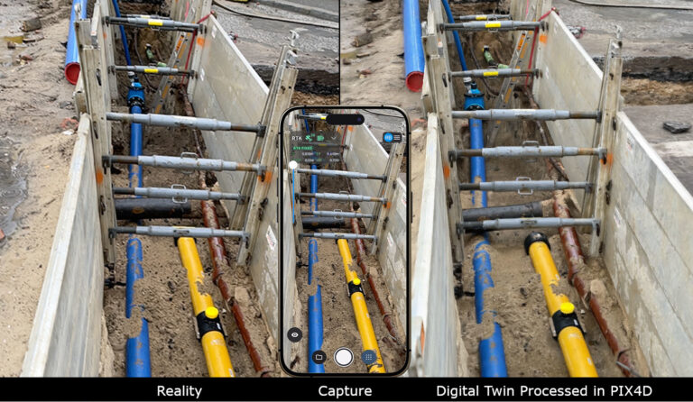
PIX4Dcatch leverages a smartphone’s camera, GPS, and (in supported devices) LiDAR sensors to capture spatially accurate images. With real-time AR guidance, users can ensure complete coverage of their target area. When paired with an RTK rover, PIX4Dcatch Pro can achieve centimeter-level accuracy, making it ideal for professional surveying and inspection tasks.

PIX4Dcloud enables users to upload images from drone surveys or those captured by PIX4Dcatch to use their proprietary photogrammetry algorithms in a cloud-based environment to generate accurate and georeferenced orthomosaics, 3D meshes, point clouds, and elevation models.
Depending on the size of the project, PIX4Dcloud can process within minutes, notifying users by email once processing is complete. Once processed, users can analyse and visualize the results. These outputs can deliver something as simple as the volume of a material stockpile or trench, to more complex insights such as virtual inspections or tracking how a site has developed over time.
From preserving the intricate details of historic landmarks in lifelike 3D to recording the precise locations of underground utilities, PIX4D opens a world of possibilities for digital capture.
If it can be seen, it can be scanned.

For professionals seeking even more control and scalability, PIX4Dmatic offers a powerful desktop solution for processing large datasets with high accuracy and speed. Ideal for corridor mapping, infrastructure projects, and high-resolution surveys, PIX4Dmatic supports seamless integration with PIX4Dcatch and drone imagery. Users can refine outputs, apply ground control points (GCPs), and export results for use in CAD, GIS, or BIM workflows.
In Conclusion, together, PIX4Dcatch, PIX4Dcloud, and PIX4Dmatic form a robust ecosystem that brings advanced photogrammetry and 3D modelling into the hands of surveyors, engineers, and digital twin creators. Whether in the field, in the cloud, or at the desktop.
Innovelec Solutions plays a key role in supporting users of PIX4D software by acting as a trusted UK-based distributor and technical partner. We provide access to the full range of PIX4D products, including PIX4Dcatch, PIX4Dcloud, and PIX4Dmatic and offer tailored advice to help our customers choose the right tools for their specific needs.
Ready to transform your site into a digital twin? Contact Innovelec to explore PIX4D solutions tailored to your needs.